Showing posts with label southern california caves. Show all posts

Scripps Park, La Jolla Sea Caves

La Jolla Sea Cave

Scripps Park in San Diego features several of the largest sea caves in Southern California. To be honest, there aren't many large, natural caves in Southern California. As a cave enthusiast, I try to explore as many as I can.

The sea caves in La Jolla are unique because they are located under the bluffs of a major metropolitan area just a hundred yards from the hotels and restaurants on the streets above.  Many of the caves are only accessible by kayak. There are several companies in La Jolla that offer guided tours and rent boats to explore the caves. I've never rented from them because I own my own boat, so I won’t vouch for any tour group in particular.

At least one cave can be reached during low tide from the beach.  It’s actually an open-ended 50 foot tunnel. When the tide is out, you will almost certainly have company, because this is a very popular beach.
One of the best things about Scripps Park is the huge population of seals who inhabit the area. On a good day, you might see a a hundred seals sunning themselves on the rocks. Scripps Park is also home to a large population of
Share:

Solstice Canyon Waterfall and Ruins, Malibu California

Solstice Canyon Ruins

 Solstice Canyon is a fun, relatively easy hike to a small waterfall and the ruins of an old mansion in the mountains above Malibu. The hike can be completed in less than an hour. This is a popular hike for families because the elevation gain is moderate and gradual. Many hikers turn this hike into a loop by crossing the creek at the waterfall and returning to Solstice Canyon via the Sostomo and Rising Sun Trails.

The loop takes you up over a larger mountain and might be too difficult for
Share:

Sturtevant Falls

Sturtevant Falls, Sierra Madre California

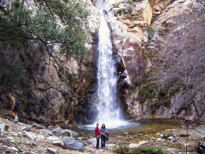
Sturtevant Falls is located a few miles North of Sierra Madre California in Big Santa Anita Canyon. The Canyon looks like something straight out of a storybook. It’s filled with cabins, oak trees, rambling brooks, stone walls and picturesque cabins.  If you’re lucky, or unlucky depending on how you look at it, you might even run into a black bear. If magic really exists in the world, you’re most likely to find it in this canyon.
The hike to the falls is approximately 4 miles round-trip from the parking area at Chantry Flats.  The trail to the falls is wide, well maintained and usually very busy.  Chantry Flats also serves as the starting point for the Mount Wilson trail, the Mount Zion trail, the Gabrielino TrailHermit Falls, Hoegees Camp, the Spruce Grove Camp and the Santa Anita Canyon Loop. Sturtevant Falls is one of the few waterfall hikes in Southern California where pets are permitted, so the trails here attract everyone from families to hardcore backpackers, but most of the casual hikers confine themselves to the Sturtevant Falls trail.

Share:

Catalina Island: Avalon

Avalon, Catalina Island

I took a day trip last week to Catalina Island for the first time. I had purchased a 2 for 1 Groupon for the Catalina Flyer which normally charges 69$ round-trip per person. The Catalina Flyer departs daily from Balboa Peninsula in Newport beach at exactly 9 am. They do not wait around for stragglers. The boat ride takes about an hour, most of which is on open ocean. It can get a little choppy on the water and the Flyer can really move. They provide barf bags for the guests on every table. The boat drops you off in the harbor in beautiful Avalon. The downtown area is filled with bars, restaurants  and gift shops. The famous Avalon casino has been converted into a movie theater. Most people in Avalon rent golf carts to get around town, but we decided to hike around town and do some exploring in the mountains above Avalon instead. We headed through town and signed in for a free hiking permit in the Nature Center. Next, we took an 8$ tour of the Wrigley Botanic Garden. The trail to the top of the mountain starts at the far end of the botanical garden, so you're forced to pay the 8$ entrance fee, or hike the murderously steep trail in reverse through the Hermit Gulch campground instead. We opted to take the easier route through the garden. As the trail winds its way up the mountain, you're views of Avalon get better. From the peak at the East End Road, you get a panoramic view of Avalon, mountains and open ocean. From there, we headed North on the Divide Road for about a mile until we hit the trail junction to Hermit Gulch Campground and headed back down the mountain to Avalon. We ate some Mexican food, checked out the Casino, and then caught the boat back to Balboa Penninsula at 4:30 pm.
The time I do Avalon, I want to plan a multi-day backpacking trip to the far North of the Island at Starlight Beach. It's about 60 miles round-trip.

Here is a link to a  great map of Catalina Island
http://www.catalinaconservancy.org/userfiles/files/maps/TCT.pdf
Catalina Island Casino


Share:

Avila Beach Pirate Cove

Avila Beach Nude Beach
Avila Beach 

Avila Beach is located approximately 3 hours North of Los Angeles just off the 101. In truth, its just a sleepy little hamlet situated at the mouth of San Luis Obispo Bay. It's like The Shire with an amazing beach. The town is mostly filled with wealthy retired people and the kind of little arts and crafts stores that your grandmal would love. Pets are allowed on the main beach, and someone in Avila must make a fortune selling poodles to the old folks because I saw at least 100 of them racing around on the sand. Avila has another beach located just South of town on the other side of the bluff. Its easily one of the most beautiful beaches I've ever seen in my life. Its a pristine undeveloped area teaming with sea lions, exotic birds, and giant acorn trees. The huge rock outcropping offers a panoramic view of the entire bay. With a little exploring, you'll find a giant pirate cove and several natural arches. The hidden cove at Avila is historically a nude beach, but we didn't actually see anyone in the buff. If you're headed North to Big Sur, I would definitely recommend taking a 2 hour detour to check out Avila. You may end up retiring there one day. To access the Pirate Cove, take the Avila Beach Drive exit off route 101 and follow it for approximately 2 miles before turning left onto Cave Landing Road. Follow Cave Landing Road for about a mile uphill until you hit the dirt parking lot. The pirate cove is located under the rock outcropping on the bluff.
Avila Beach

Avila Beach Pirate Cove

Share:


Popular Posts

Labels Cloud